 |
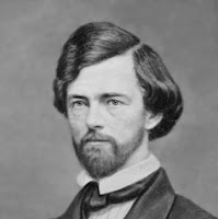
| Governor Stevens. Library of Congress. |
In theory, a northern route to supplement the Oregon Trail would encourage Washington settlement, one of the Governor’s cherished goals. But mostly he hoped that a rail line would make Puget Sound a commercial gateway to the Orient. A fast clipper ship could reach Shanghai three or four days sooner sailing from Seattle as compared to San Francisco … saving about a week on the round trip.
The Army’s concern arose from the growing unrest among the Indians of eastern Washington. Troops stationed in the region could be supplied more easily by a road that connected with the head of steamboat navigation on the Missouri River. But a railway was most likely years in the future, so they saw a military road as a practical answer to their supply needs.
Shortly after his appointment as Governor, in 1853, Stevens had lobbied hard for a survey of a northern route. Naturally, as a trained engineer and surveyor, he could lead the expedition on his way west to take office. The lobbying succeeded, and his party started from Minnesota in June 1853. The expedition completed the survey to Fort Vancouver five months later.
But funding to build the road was slow in coming. Then, two years after Stevens completed the survey, the general Indian unrest exploded into the Yakima War. In the ensuing conflict, the Army had to make do with the supplies they had, with re-supply via the Oregon Trail. The series of conflicts continued into late 1858, and served to emphasize the need for the road. Funds were provided just months after the uprisings were suppressed.
Lieutenant John Mullan led crews east from Walla Walla in the spring of 1859. Their route headed north-northeast until it was more or less even with the south edge of Lake Coeur d’Alene, where it turned east. Skirting the lake, the road continued up the course of the Coeur d’Alene River and crossed into Montana.
 |
| John Mullan. Center for the Rocky Mountain West, University of Montana. |
Of course, planners had grossly underestimated the cost of cutting a road through such rough country. By the time crews reached Fort Benton, in August 1860, expenses had escalated substantially. Washouts raised the price even further. In fact, part of the road had to be rerouted, including a major diversion to the north of Lake Coeur d’Alene. In the end, the road cost about $230,000, more than double the original estimate.
As it turned out, the military made very little use of the road – which is probably why no money was ever appropriated for routine maintenance. However, it has been estimated that as many as 20,000 civilians traveled the road the very first year after it was completed.
Later roads and rail lines followed the same route to serve the Couer d'Alene mining towns – Wallace, Kellogg, Mullan, and so on – and today's Interstate-90 highway follows much the same course.
| References: [French] |
| Randall A. Johnson, “Captain Mullan and His Road,” The Pacific Northwesterner, Vol. 39, No. 2 (1995). [Reprinted at HistoryLink.org ] |
| John Mullan, Report on the Construction of a Military Road from Fort Walla Walla to Fort Benton, Ye Galleon Press (May 1989). |
| “The Mullan Road,” Reference Series No. 287, Idaho State Historical Society (December 1964). |
| David Wilma, “Stevens, Isaac Ingalls (1818-1862),” Essay 5314, HistoryLink.org, Online Encyclopedia of Washington State History. |
